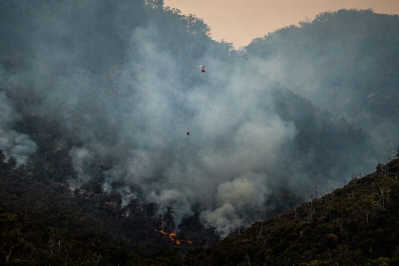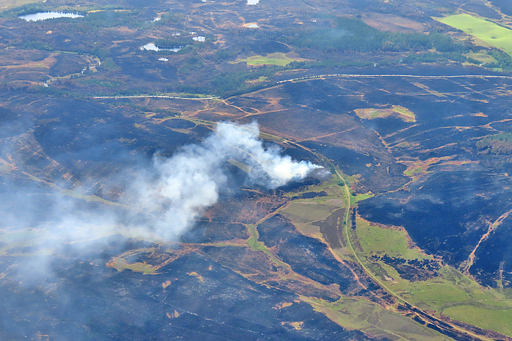
In 2025, the UK witnessed its first megafire. Over June-July 2025, the Dava and Carrbridge fires in the Scottish Highlands burned 11,827 hectares, meeting the commonly used threshold of a megafire (burned area over 10,000 hectares) for the first time in UK records and marking a major shift in the scale of wildfire experienced in the United Kingdom.
The area burned as a result of this fire was as large as the average area burned over a whole year in the entire UK, and roughly twice as large as the nation’s next-largest fire in the last 20 years (Schoenecker et al., 2026). As the fires occurred over carbon-rich peat soils, the fires emitted nearly a year’s worth of fire emissions in four days, amounting to nearly 40,000 tonnes of carbon.
The 2025 fire season was not just notable for the largest UK fire on record. It also holds the record for the largest total burned area and number of fires, while 2026 exceeds this for total fire emissions and severity rating, according to EFFIS. Other major fires of 2025 include the Langdale Moor wildfire in North Yorkshire, which was ignited on 11 August and burned for over six weeks. Similarly over 2026 we have seen another unprecedented fire season with devastating impacts for communities across the UK, including major fires in Stourbridge, Conwy Mountain and Tintwistle Moor. As we move into a warmer climate, the risk of more extreme fires for the UK starts to become more real.
From early growth to rapid drying: the hydroclimatic drivers of the Dava and Carrbridge fires
The exceptional extent of the Scottish megafires cannot be explained by the weather on the days of the fires alone – the foundations for the 2025 season were set months earlier. Spring 2025 was the warmest and sunniest on record, around 1.4 °C warmer than the long-term UK average, while the UK received just 56% of average precipitation. These conditions, summarised in Figure 1, created an extended period of fuel drying just as grasses, heather, and other surface vegetation emerged. Instead of entering summer with moisture-replenished soils and resilient live fuels, large parts of the landscape were already primed for fire activity (State of Wildfires, 2026). At Dava and Carrbridge, the combination of vegetation growth, subsequent drying and continuous surface fuels provided conditions in which fire could spread across an unusually large area.
By late June, fire weather (the combined effect of high temperature, strong winds and low humidity) acted on a landscape that had already undergone months of preconditioning. Large-scale warm conditions and low moisture increased the potential for fires to take hold and spread, while dry grasses and heather across moorlands and heathlands provided connected pathways across the landscape. The fires persisted for several days and were ultimately suppressed only after substantial rainfall.
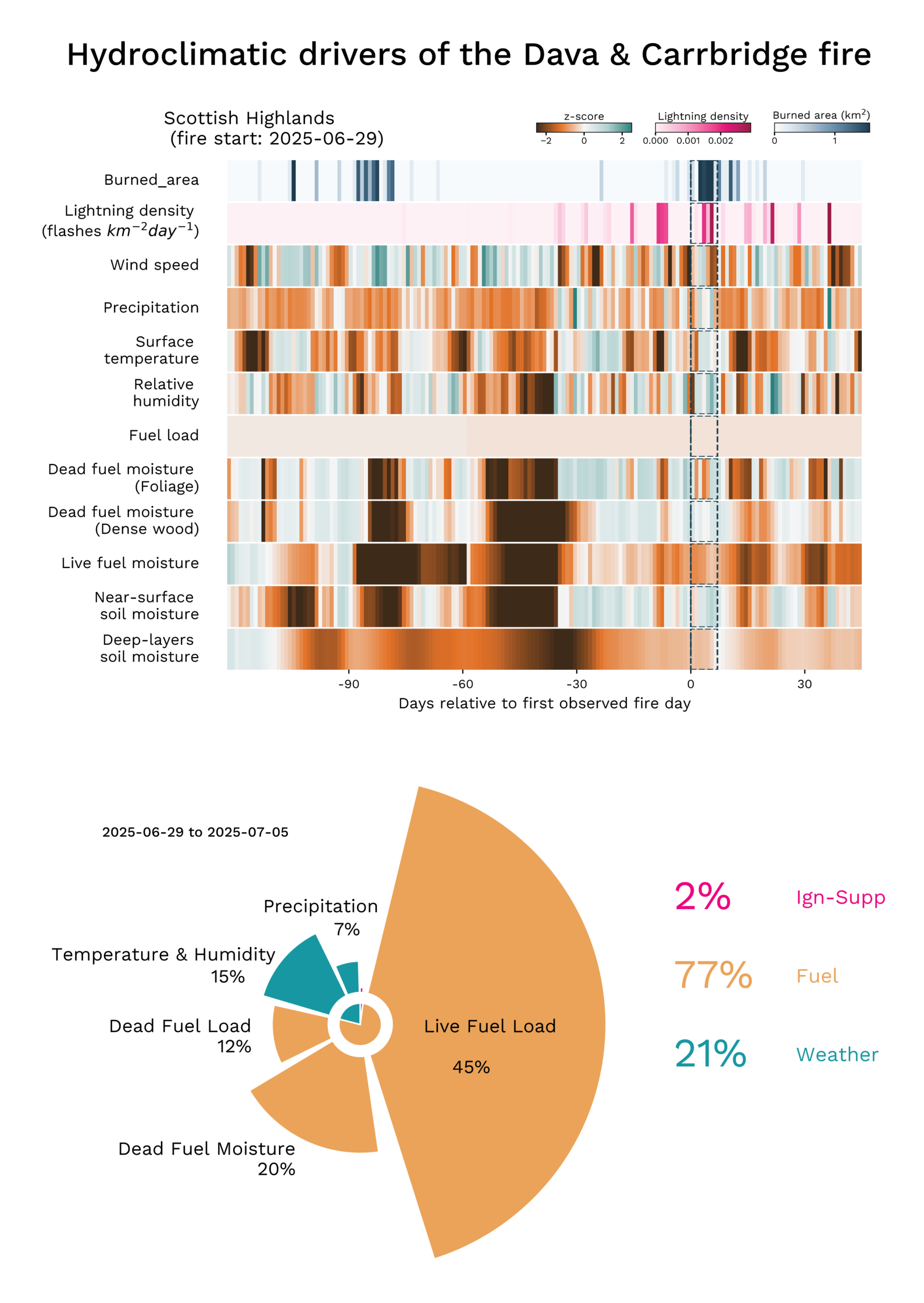
Figure 1: Hydroclimatic drivers of Scotland’s wildfires. The upper panels show anomalies in weather, fuel and soil conditions during the 120 days preceding the event and up to 30 days after the start. Anomalies are expressed as z-scores, indicating the number of standard deviations above or below the mean climatological conditions. Orange indicates conditions favourable for fire, while teal indicates unfavourable conditions. The lower panel summarises the contributions of individual predictors to the predicted probability of fire occurrence, grouped into fuel, weather and ignition factors. Fuel conditions were the dominant driver, accounting for 77% of the total attributed contribution to the predicted probability of the event. Credit: Francesca Di Giuseppe, Joey McNorton, ECMWF
How are UK fire regimes changing?
Wildfires are not traditionally associated with the UK. Cool temperatures, frequent rainfall and fragmented landscapes have historically limited the large, fast-moving fires most common in boreal forests and savannas. However, the 2025 wildfire season challenged this perception, highlighting an emerging risk driven by increasingly extreme weather (State of Wildfires, 2026).
The fire season in the UK has traditionally peaked in Spring, typically around April, when dead vegetation left over from the previous year has dried out and can ignite easily. Fire weather is often high at this time, with sunny, dry days, low humidity and breezy conditions. UK fires are often driven by fine fuels, which dry out easily. In summer, vegetation is at peak growth and contains higher moisture, because UK summers have historically been mild with regular rainfall.
However, this pattern is beginning to change. In some parts of the UK, we are now seeing longer dry seasons and hotter, drier summers, leading to larger fires for longer periods across the year, and a stronger secondary summer fire season.
Northern Scotland presents a more mixed picture. While some months have become wetter, others show signs of becoming drier later in the summer, particularly over the Dava region in August (State of the UK Climate, Kendon et al., 2025). Our preliminary analysis of observations for Northern Scotland (Figure 2) using ERA5-Land suggest a small and uncertain shift towards generally drier springs and wetter summers. However, with continued warming, the atmosphere’s ability to draw moisture from soils and vegetation has increased (represented by Dry Heat), and periods of compound hot, dry and windy weather have increased in both seasons as a result of climate change. This assessment is based on a single observational dataset and so doesn’t provide a complete picture of changes in fire weather, but points towards conditions that can increase the risk and severity of wildfires.
Fires in Scotland can often differ in nature from those further south in the UK, with more frequent cold fires such as the blaze on the Isle of Skye in February 2021. Together with the importance of dry fuel accumulation in the case of the Dava & Carrbridge fire, traditional metrics such as Fire Weather are less useful for attributing the role of climate change in weather drivers. This particular fire in Scotland was a relatively localised event, which made it difficult to assess using climate models that operate at a much coarser scale and aren’t able to fully capture the complex landscape, wind patterns and coastline of the area.
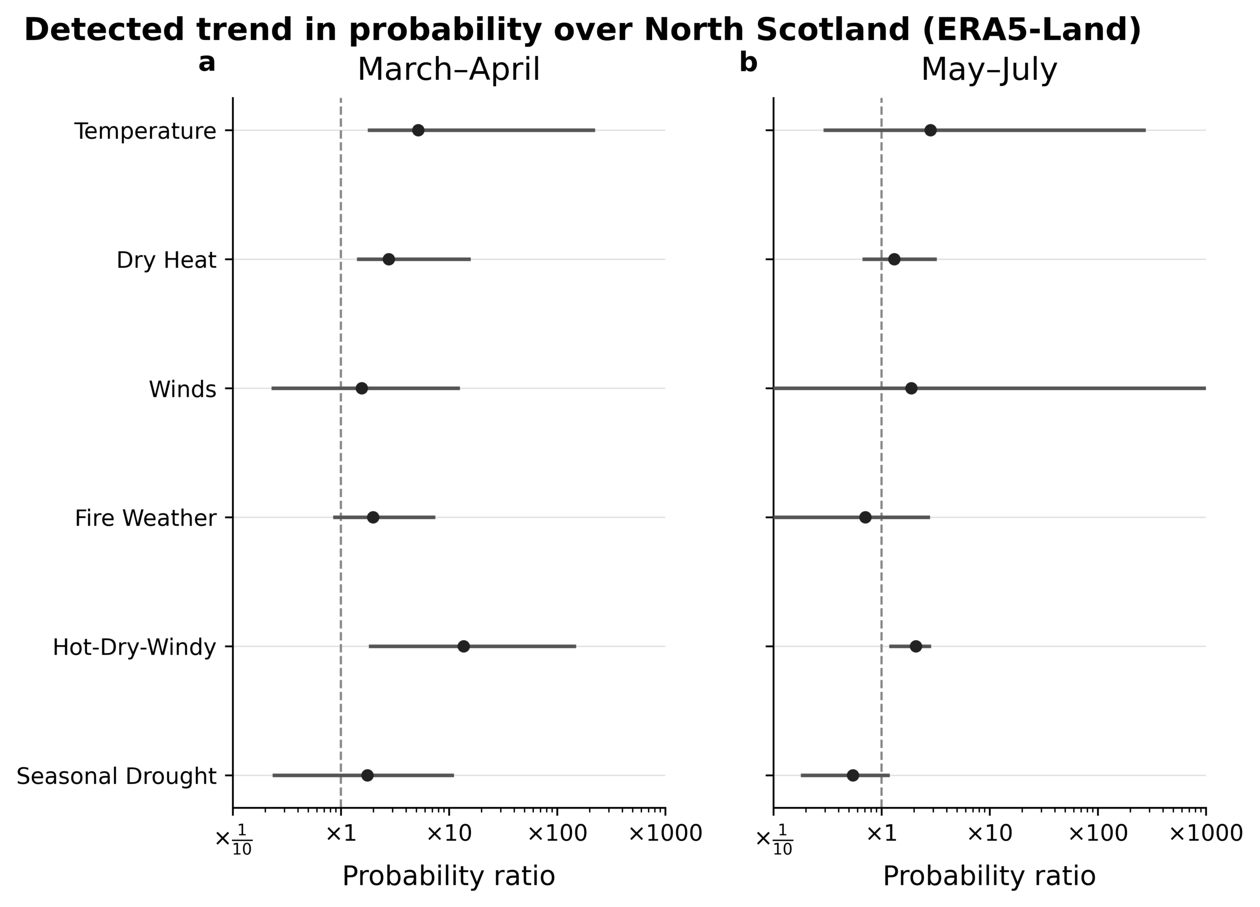
Figure 2: Climate change increases probability of hot, dry conditions. Probability Ratio for a 10-year event of individual drivers in North Scotland over the Spring (March-April) and Summer (May-August) fire season. Points over the dashed line indicate an increase in likelihood in today’s climate compared to pre-industrial times. Variables were analysed for the most severe 7-day period as follows: daily maximum temperature; daily maximum Vapour Pressure Deficit (‘Dry Heat’), daily maximum wind speed (Winds), the Canadian Fire Weather Index (‘Fire Weather’), the Hot-Dry-Windy Index. Seasonal Drought over MAM and JJA was also assessed using a 3-month standardised precipitation evapotranspiration index (SPEI). The best estimate according to the World Weather Attribution protocol (Philip et al., 2020) is shown as a central dot, and the 95% confidence interval shown as an error bar. Credit: Theodore Keeping, WWA (Data available on request).
What the future might hold for UK fire
Through the State of Wildfires project, we have developed tools that allow us to apply locally observed relationships between weather, fuel conditions, and wildfire activity for possible future fire risk over the UK for the rest of this century.
Preliminary analysis using models calibrated with observations of UK weather, vegetation, and fires show that, under a high-emissions future (SSP3-7.0), annual burned area is projected to increase by around 24% by the end of the century, with particularly severe years experiencing up to 3.8 times more burned area (Figure 3). The largest changes occur for the rarest wildfire seasons. By the end of the century, a season comparable to a present-day one-in-ten-year event is projected to occur around 70% more often, while today’s one-in-100-year wildfire seasons could become more than twice as likely. Strong emissions reductions can considerably reduce these increases, particularly for the most severe events.
The largest increases are projected for many upland and western landscapes, including parts of Wales, the Scottish Highlands and western England – this is despite the increase in rainfall. Notably, several of these regions have already experienced major fires during the exceptional 2025 and 2026 seasons.
These projections are broadly consistent with earlier studies based on fire weather indices such as the Fire Weather Index (FWI). Previous research has shown that climate change is projected to substantially increase hazardous fire weather across the UK, particularly in summer, with the number of days experiencing “very high” fire danger projected to double at 2°C of global warming above pre-industrial levels compared to 1981-2010 (Perry et al., 2022). Other studies suggest that the wildfire season is likely to lengthen into late summer and autumn as temperatures continue to rise (Leckebusch and McCarthy, 2026). Together, these studies point towards a future with more frequent and severe wildfire conditions across the UK.
Building resilience to fires in the UK
Understanding and preparing for future UK wildfire risk will require continued improvements in observations, modelling and forecasting. Higher-resolution climate, vegetation and fire weather modelling, combined with improved surface wind observations, will help us better capture the local conditions that drive fire behaviour and identify where the greatest risks are emerging. In parallel, developing a regionalised fire weather index could provide a more accurate assessment of wildfire risk by reflecting the country’s unique vegetation, climate and fire regimes.
Through the State of Wildfires project, we are working to develop the tools needed to better understand, anticipate and manage changing wildfire risk across the UK. At the same time, strengthening UK wildfire resilience is not only a scientific and technical challenge.
A continuous dialogue between science, policy and practice will be essential to translate advances in wildfire research into effective decision-making, helping communities anticipate, prepare for and recover from increasingly severe fire seasons. As fires such as Dava and Carrbridge become increasingly plausible in a warming climate, building UK wildfire resilience will be critical to adapting to a more fire-prone future.
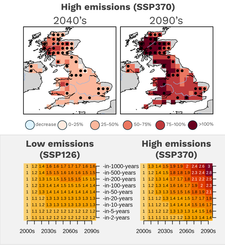
Figure 3: A hotter future means bigger and more frequent wildfire years. The maps highlight parts of the UK where large increases in burned area are most likely under a high-emissions future, showing the percentage amplification of burned area under a likely worst-case scenario. They should be interpreted as hotspots of future risk rather than forecasts of exactly where fires will occur. The chart below shows how today’s rare wildfire years become increasingly common over time. Strong emissions reductions can limit many of the largest increases, but even under a low-emissions future, extreme wildfire years are projected to occur more often than they do today.
Recent Articles
A look at Europe’s wildfire season of 2026
October 2026
How Climate Change Is Reshaping the Fire Management Calendar
September 2026
When a wildfire builds a thunderstorm
August 2026