The 2026 wildfire season has been exceptional across Europe in both scale and geographical extent. By 16 September, the European Forest Fire Information System (EFFIS) had mapped 666,534 hectares of burned area across the European Union—approximately 4.2 times the area of Greater London. During July and August alone, EFFIS identified 2,037 fires larger than 30 hectares and 19 individual fires exceeding 10,000 hectares, a threshold commonly used to define megafires in Europe. Spain, Italy and France together accounted for around three quarters of the total burned area. France reached approximately 6.6 times its 2006–2025 climatological mean, while Portugal recorded the largest proportion of national territory burned, at approximately 0.74%.
Through 16 September, the 2026 fire season ranked as the second-highest on record for burned area in Europe. It follows the exceptional 2025 season, which remains the largest on record, with more than 1 million hectares burned.
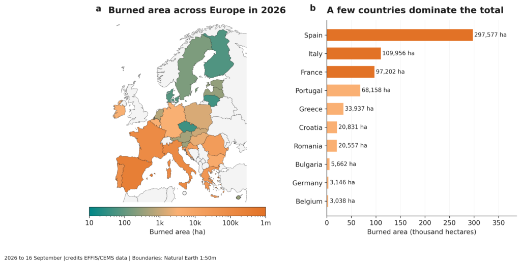
Figure 1 | Burned area across Europe during the 2026 fire season. a, Country-level burned area mapped by the European Forest Fire Information System (EFFIS) up to 16 September 2026. b, Countries with the largest cumulative burned area over the same period. Spain dominated the season, followed by Italy and France, with these three countries accounting for a third of the European total. Data: EFFIS/Copernicus Emergency Management Service; country boundaries: Natural Earth.
France and Spain: a simultaneous crisis
The season’s severity became particularly clear in July, when major wildfire emergencies developed simultaneously in France and Spain. More than 300,000 people were evacuated across both countries, and both required assistance from other European countries.
The two regions also shared a similar hydroclimatic sequence. Winter rainfall was exceptionally high: mainland Spain received 171% of its normal winter precipitation, while accumulated rainfall in Portugal by the end of February was around 1.8 times the long-term average. These wet conditions supported vegetation growth and increased biomass. This was followed by a rapid transition towards drying: in Portugal, April rainfall fell to just 38% of normal, while across Iberia soil and fuel moisture progressively declined. By early July, substantial fuel availability coincided with extreme fire weather: temperatures reached 35–41°C across much of Spain, locally 43°C, while FWI values reached 54–66 and locally approached 90. The most severe fires were therefore not simply the product of conditions on the day of ignition, but of several months of hydroclimatic preconditioning.
In southwestern France, the Gironde fires also illustrated how extreme wildfire activity can begin to modify the atmosphere itself. Intense fire heating generated deep convection and a documented fire-generated thunderstorm. As heated air rises, condensation and latent heat release can support deeper ascent, allowing a wildfire plume to develop into a pyrocumulonimbus. Such systems can produce lightning, gusty outflows and long-range spotting, adding further complexity to already extreme fire behaviour.
A broader European signal
The events of 2026 fit within a wider increase in extreme fire weather across Europe. Climate trends indicate that warming substantially raises the probability of extreme Fire Weather conditions, particularly in Mediterranean regions, while also lengthening fire seasons. Projections for temperate forests (which would include the Mediterranean in our definition) indicate an increased average burned area and, potentially more importantly, a positive trend in extreme fire activity under all SSP scenarios out to 2100. This is particularly evident in NW Iberia.
A particularly important change is increasing synchronicity: extreme fire-weather conditions affecting larger areas at the same time. Comparing 2002–2022 with 1981–2001, the summer area simultaneously experiencing FWI values above 50, the threshold used by EFFIS to denote extreme fire danger, increased by 271% in Central Europe and by 19% in the Mediterranean. This corresponds to an additional 21,440 km² and almost 130,000 km², respectively, experiencing extreme fire-weather conditions simultaneously.
Climate-change attribution of the July 2026 episode provides further context. In central Spain, the observed fire-weather conditions were estimated to have become at least 20 times more likely than in a pre-industrial climate. In southwestern France, they were estimated to be at least twice as likely. These figures refer to fire weather, not directly to ignition or burned area, but they show how the climatic background for severe fires is changing.
The geographical footprint of the 2026 season was also broader than the large Mediterranean burned area totals alone suggest. Figure 2 shows that several countries where wildfire activity is normally comparatively limited—including Belgium, the Netherlands, Slovakia and parts of central and eastern Europe—recorded burned area above their 2006–2025 mean. Their absolute contribution to the European total remained small compared with Spain, France and Italy, but their relative departures were substantial. Because historical burned area is low in these countries, even modest absolute increases can translate into large anomalies; these values should therefore not be interpreted as Mediterranean-scale fire seasons. Instead, they show that unusually elevated fire activity in 2026 extended beyond Europe’s traditional wildfire hotspots and illustrate why both absolute burned area and departures from local climatology are needed to understand the continental season.
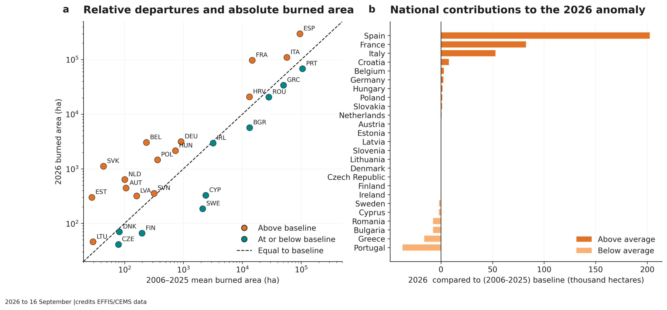
Figure 2 | Absolute and relative departures in European burned area during 2026. a, Cumulative burned area up to 16 September 2026 compared with the corresponding 2006–2025 country mean. The dashed line denotes equality with the historical mean; countries above the line experienced more burned area than their baseline. b, Absolute contribution of each country to the 2026 departure from the 2006–2025 mean. Spain, France and Italy dominate the positive anomaly in absolute terms, whereas several countries with historically low burned area also lie substantially above their national baseline. Data: EFFIS/Copernicus Emergency Management Service.
Shared resources and growing impacts
The practical consequence of greater synchronicity is that several countries may require substantial firefighting support at the same time, placing pressure not only on national resources but also on shared European response capacity. Through the EU Civil Protection Mechanism (UCPM), countries can request assistance from other participating states, while rescEU provides an additional strategic reserve of firefighting aircraft when national and pooled capacities are insufficient. During the July 2026 crisis, France received seven planes and four helicopters through the mechanism, while Spain simultaneously received six planes, 134 personnel and 41 vehicles. When severe fire weather affects several regions simultaneously, demand for these shared aircraft, crews and equipment can therefore increase at the same time, constraining the pool of assistance available for further deployments.
Across the season, ten activations of the EU Civil Protection Mechanism had been reported by 25 August. Coordinated deployments involved more than 700 firefighters, over 200 vehicles and 38 aircraft. Preliminary economic estimates for France, Spain and Greece alone ranged between €15.6 billion and €19.1 billion.
The exceptional nature of the 2026 European fire season therefore lies not only in the amount of land burned. It reflects the combination of severe hydroclimatic preconditioning, simultaneous crises across countries, extreme fire–atmosphere interactions, and a broader trend toward more frequent and more synchronous fire weather. For Europe, this increasingly turns wildfire from a series of national emergencies into a shared continental challenge.
Recent Articles
How Climate Change Is Reshaping the Fire Management Calendar
September 2026
When a wildfire builds a thunderstorm
August 2026